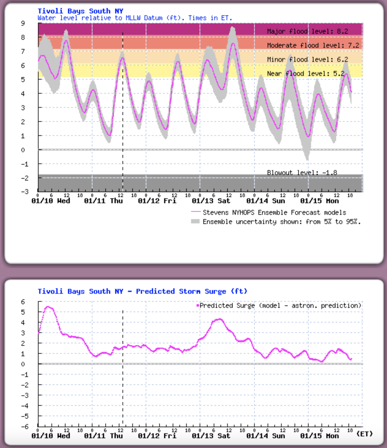
NYCDEP reported closure of the Ashokan Release Channel for a 10-hour period on Sunday, March 24th from around midnight to 10:00 AM, prompted by the Esopus Creek at Mt. Marion stream gage exceeding the “Action Stage” of 18ft. Afterwards, the Ashokan Release Channel was gradually reactivated to a flow of 440 MGD (681 CFS). As of Monday, March 25th, the release turbidity is 2.7 NTU, Ashokan Reservoir storage is at 98.3%, above the Conditional Seasonal Storage Objective (CSSO) of 92.3%. The Catskill Aqueduct is online and diverting 375 MGD (580 CFS) for water supply. NYCDEP will continue to monitor conditions and make additional release adjustments pursuant to the Interim Release Protocol (IRP).
All posts by admin
Community Forum for Lower Esopus Implementation Plan
Share your thoughts and discuss upcoming plans!
When: March 28th at 6:00PM
Where: Town of Ulster Senior Center, 1 Town Hall Drive
Lake Katrine, NY 12449
How: Please register via Eventbrite to attend in-person or online.
This forum aims to gather your valuable feedback on future projects for the Lower Esopus Creek. Two million dollars in funding is available to support these projects, and your input will help guide which projects these funds will support. Ulster County, along with consultants and an advisory council, has integrated insights from the summer outdoor and winter indoor workshops, public survey, stream assessment and resulting stream management plan. A draft list has been prepared of priority projects that will improve the health of the Creek. This latest input session presents another opportunity learn about the plan and to contribute to the future of the Creek.
Ashokan Release Adjustments
The Ashokan Release Channel was shut down over the weekend in response to the rising Esopus Creek water level at the Mt Marion gauge. With the Mt Marion dropping below Action Stage, the Ashokan Release Channel was reactivated on Monday, March 11th, increasing from 0 MGD to 420 MGD in a series of steps. NYSDEP will continue to monitor conditions and make additional adjustments pursuant to the Interim Release Protocol.
As of March 11, the current release turbidity is 5.3 NTU, Ashokan Reservoir storage is 97.7%, and the Catskill Aqueduct is online diverting 310 MGD for water supply.
Army Corps plans dredging of Saugerties Harbor
According to the U.S. Army Corps Fact Sheet for Saugerties Harbor, maintenance dredging is planned for fiscal year 2024 in the tidal Esopus Creek. Existing environmental restrictions require all in-water work to be completed between August 15th and October 31th. More information is available here: Fact Sheet – Saugerties Harbor, New York
A survey of the channel from last year shows areas less than the controlled depth of 12′ in the mouth of the creek near the lighthouse and within the inside bend of the creek on north side along Lighthouse Drive. See yellow-shaded areas within the channel boundary on the Saugerties Harbor Condition Survey 2022.
Dredging will not reduce flood risk along in the tidal zone. The level of water in the tidal portion of the Esopus Creek is minimally affected by the shape or depth of the channel bottom at high tide. No matter how deep the channel is, the tide reaches an elevation established by the water surface elevation in the Hudson River.
Comment deadline for stream management plan
Reminder: the deadline to submit comments on the draft Lower Esopus Stream Management Plan is Monday, January 22nd.
To read the draft SMP and access the comment form, visit https://loweresopussmp-ulstercounty.hub.arcgis.com/
Ashokan releases adjusted
This morning the Ashokan Release Channel flow was increased from 300 MGD (464 cfs) to 450 MGD (696 cfs) to help reach the seasonal storage objective and to maintain a combined spill and release flow less than 1000MGD. The turbidity of water in the release channel is 14.9 NTU.
Ashokan Reservoir storage is 101% today. The reservoir started spilling on Sunday and is forecast to continue spilling through Saturday. The Catskill Aqueduct is online diverting 175 MGD for water supply.
Release channel reactivated, reservoir spilling
The Ashokan Release Channel was reactivated after the stream level at Mount Marion dropped below Action Stage. The current release flow is 300MGD and turbidity is 17.5 ntu.
Ashokan Reservoir storage reached 100% and starting spilling overnight Sunday, January 14th. DEP will monitor the spill and release flow rates to ensure that combined total is less than 1000MGD (1550 cfs), adjusting the release rate accordingly. The Catskill Aqueduct is online diverting 125 MGD for water supply.
DEP will continue to monitor conditions and make additional adjustments pursuant to the IRP.
Tidal Flooding from Winter Storm Gerri, 1/13/24
On January 13, 2024, the water level at Saugerties (Turkey Point, Hudson River tide gauge station) peaked at 3 PM at 8.42 feet above MLLW. This water level was confirmed by observation at the Saugerties Lighthouse where waves splashed over a brass benchmark on the seawall, elevation 8.55′ MLLW. This was 4′ above the normal high tide and exceeded winter storm Elliot on December 23rd, 2022, which crested at 8.3 feet MLLW.
This was the second time within a week and third time in a month that the water level at Saugerties reached or exceeded 8′ MLLW due to tidal storm surge: Monday, December 18, 2023; Wednesday, January 10 and Saturday, January 13, 2024.
Note that the level of water in the tidal Esopus Creek when the tide is high is minimally affected by the shape or depth of the channel bottom. No matter how deep the channel is, the tide reaches an elevation established by the water surface elevation in the Hudson River as indicated by the Turkey Point tide gauge.
Release channel shutdown in response to rainfall runoff
The Ashokan Release Channel was shut down at 09:00am today, January 13, 2024, with the Mount Marion stream gage reaching action stage of 18ft. The Esopus Creek is expected crest at 19.1 feet. The release channel will be reactivated once stream conditions recede below 18ft.
Tidal flooding expected on Saturday
Winter Storm Gerri is forecasted to generate 3 to 4 feet of tidal surge on Saturday afternoon, January 13th, similar to recent flooding caused by Winter Storm Finn on Wednesday. The Stevens Flood Advisory System predicts water levels at least 7 feet above Mean Low Low Water (MLLW) at high tide on Saturday afternoon, which is 3PM at Saugerties. Flooding may cover the pavement of Lighthouse Drive at high tide.

The level of water in the tidal portion of Esopus Creek is minimally affected by the shape or depth of the channel bottom at high tide. No matter how deep the channel is, the tide reaches an elevation established by the water surface elevation in the Hudson River as indicated by the Turkey Point tide station.


