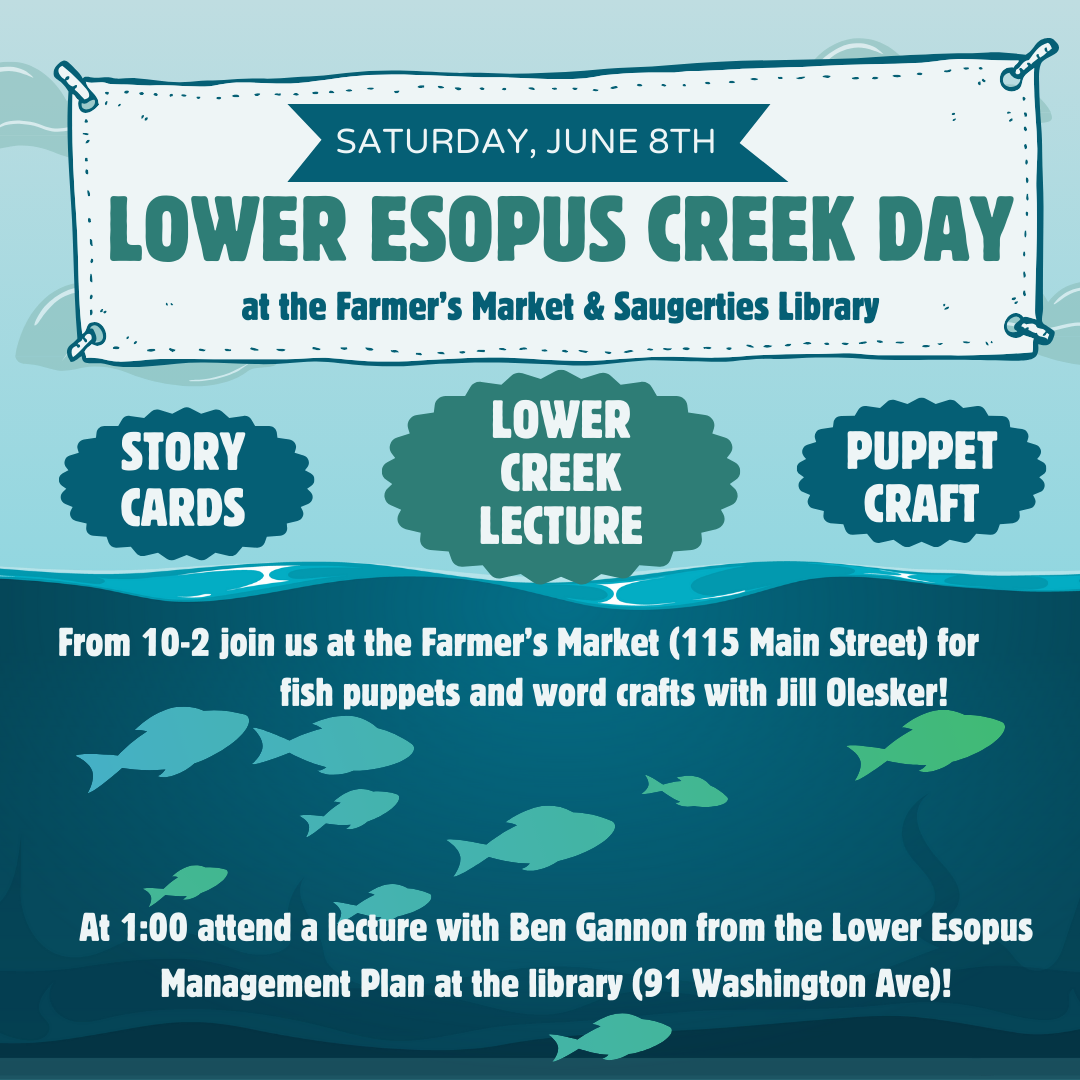
All posts by admin

Ashokan releases adjusted

This morning the Ashokan Release Channel flow was increased from 300 MGD (464 cfs) to 450 MGD (696 cfs) to help reach the seasonal storage objective and to maintain a combined spill and release flow less than 1000MGD. The turbidity of water in the release channel is 14.9 NTU.

Ashokan Reservoir storage is 101% today. The reservoir started spilling on Sunday and is forecast to continue spilling through Saturday. The Catskill Aqueduct is online diverting 175 MGD for water supply.

Release channel reactivated, reservoir spilling

The Ashokan Release Channel was reactivated after the stream level at Mount Marion dropped below Action Stage. The current release flow is 300MGD and turbidity is 17.5 ntu.

Ashokan Reservoir storage reached 100% and starting spilling overnight Sunday, January 14th. DEP will monitor the spill and release flow rates to ensure that combined total is less than 1000MGD (1550 cfs), adjusting the release rate accordingly. The Catskill Aqueduct is online diverting 125 MGD for water supply.

DEP will continue to monitor conditions and make additional adjustments pursuant to the IRP.

Tidal Flooding from Winter Storm Gerri, 1/13/24

Waves splashed over the seawall at the Saugerties Lighthouse on Saturday, January 13th.

On January 13, 2024, the water level at Saugerties (Turkey Point, Hudson River tide gauge station) peaked at 3 PM at 8.42 feet above MLLW. This water level was confirmed by observation at the Saugerties Lighthouse where waves splashed over a brass benchmark on the seawall, elevation 8.55′ MLLW. This was 4′ above the normal high tide and exceeded winter storm Elliot on December 23rd, 2022, which crested at 8.3 feet MLLW.

Screenshot of Turkey Point tide gauge cresting at 8.42′ MLLW on Saturday, January 13th .

This was the second time within a week and third time in a month that the water level at Saugerties reached or exceeded 8′ MLLW due to tidal storm surge: Monday, December 18, 2023; Wednesday, January 10 and Saturday, January 13, 2024.

Note that the level of water in the tidal Esopus Creek when the tide is high is minimally affected by the shape or depth of the channel bottom. No matter how deep the channel is, the tide reaches an elevation established by the water surface elevation in the Hudson River as indicated by the Turkey Point tide gauge.

Tidal flooding expected on Saturday

Winter Storm Gerri is forecasted to generate 3 to 4 feet of tidal surge on Saturday afternoon, January 13th, similar to recent flooding caused by Winter Storm Finn on Wednesday. The Stevens Flood Advisory System predicts water levels at least 7 feet above Mean Low Low Water (MLLW) at high tide on Saturday afternoon, which is 3PM at Saugerties. Flooding may cover the pavement of Lighthouse Drive at high tide.

Stevens Flood Advisory System forecast for Tivoli/Saugerties showing predicted surge of 3 or greater coinciding with high tide on Saturday with water levels likely 7.5′ MLLW or greater.

The level of water in the tidal portion of Esopus Creek is minimally affected by the shape or depth of the channel bottom at high tide. No matter how deep the channel is, the tide reaches an elevation established by the water surface elevation in the Hudson River as indicated by the Turkey Point tide station

Release channel re-activated

The Ashokan Release Channel has been re-activated after a shutdown during Winter Storm Finn. Now that Mt. Marion stream gauge has dropped below the action stage of 18 ft,  NYCDEP will resume releases, increasing from 0 MGD to 600 MGD (928 cfs) in a series of steps that started today, January 11, at approximately 8 AM and will continue throughout the day concluding on or about 7:00 PM.

The releases are operating according to the Interim Release Protocol (IRP) to draw reservoir storage toward the seasonal storage objective of 90%. Ashokan Reservoir storage is 96.4 % today. Turbidity of the water in the release channel is 16.0 NTU. The Catskill Aqueduct is online at a flow rate of 550 MGD.

NYCDEP will continue to monitor conditions and make additional adjustments pursuant to the IRP, which stipulates shut down of release channel when creek level is within 1 foot of the “Action Stage” (18′) and is forecasted to reach “Action Stage”, as predicted on the National Weather Service forecast for Mt Marion stream gauge.

Flooding at Saugerties, January 10, 2024

Storm tide from Winter Storm Finn covered Lighthouse Drive at noon on January 10, 2024.

Winter Storm Finn delivered tidal flooding to the Saugerties waterfront midday on Wednesday, January 10, 2024, and Winter Storm Gerri is forecasted to deliver similar flooding on Saturday. On Wednesday morning, the Battery tide gauge in Manhattan registered a surge over 4 feet at low tide and nearly 3 feet at high tide. This surge continued up the Hudson River, and runoff from over 2″ of rainfall on snow overnight added to the tidal surge. According to the Turkey Point tide gauge, the water level crested above 8 feet, which was over 3.5 feet above normal high tide and slightly higher than flood levels on December 18, 2023. At high tide today at 12:15PM in Saugerties, the pavement of Lighthouse Drive was covered in water.

Turkey Point tide gauge showed the water level crested at 8.09 feet at high tide, nearly 3.7 feet above normal.

Tracking Winter Storm Gerri, the Stevens Flood Advisory System at Davidson Laboratory is forecasting 3 to 4 feet of surge on Saturday afternoon at high tide, bringing the water back up to similar levels as Finn. High tide is at 3PM on Saturday, January 13 at Saugerties.

The level of water in the tidal portion of Esopus Creek is minimally affected by the shape or depth of the channel bottom at high tide. No matter how deep the channel is, the tide reaches an elevation established by the water surface elevation in the Hudson River as indicated by the Turkey Point tide station

Screenshot of Stevens flood forecast for Tivoli/Saugerties showing surge predictions for Winter Storms Finn and Gerri. For the latest forecast, visit the Stevens Flood Advisory website.

Release channel ready for shut down in response to rainfall

NYCDEP said it is prepared to shut down the release channel when the Lower Esopus water level rises. The Interim Release Protocol (IRP) stipulates shut down of release channel when creek level is within 1 foot of the “Action Stage” (18′) and is forecasted to reach “Action Stage”, as predicted on the National Weather Service forecast for Mt Marion stream gauge.

The Mount Marion forecast from the National Weather Service predicts the river stage to reach action level overnight Tuesday and peak near 19.9 feet by noon on Wednesday, January 10th.

The Ashokan Release Channel is continuing to operate at its maximum rate of 600 MGD (928 cfs) today and has been operating at this rate since December 22. Ashokan Reservoir storage peaked on December 22 at 99.4% and has been on the decline since. Ashokan Reservoir storage is currently at 93.9%, and the turbidity of the water in the release channel is 15.9 NTU. The Catskill Aqueduct is online and diverting 550 MGD for water supply. The release channel is prepared to shut down when water level reached 17 ft at Mt Marion stream gauge.

For the latest information see the Mt Marion stream gauge.