To celebrate Lower Esopus Creek Day, the Saugerties Public Library will host educational activities for children featuring fish puppets and word crafts at the Saugerties Farmers Market (115 Main Street) from 10 AM to 2 PM, led by Jill Olesker of the Water Stories Project.
At 1 PM in the library (91 Washington Avenue), Ben Gannon of the Ulster County Department of the Environment will discuss the Lower Esopus Management Plan. A great way to learn about the creek!
You must register with the Participate Ulster site to give your feedback. It only requires your name and email to register. Just use any of the links above to navigate to the site, click “Register” in the upper right hand corner, and follow the instructions.
Questions on the Stream Management Plan can also be submitted through the Participate Ulster site.
Once again, deadline for comments is April 11, 2024.
Where: Town of Ulster Senior Center, 1 Town Hall Drive Lake Katrine, NY 12449
How: Please register via Eventbrite to attend in-person or online.
This forum aims to gather your valuable feedback on future projects for the Lower Esopus Creek. Two million dollars in funding is available to support these projects, and your input will help guide which projects these funds will support. Ulster County, along with consultants and an advisory council, has integrated insights from the summer outdoor and winter indoor workshops, public survey, stream assessment and resulting stream management plan. A draft list has been prepared of priority projects that will improve the health of the Creek. This latest input session presents another opportunity learn about the plan and to contribute to the future of the Creek.
Map of Saugerties Harbor Federal Navigation Channel (SHFNC) shown in white.
According to the U.S. Army Corps Fact Sheet for Saugerties Harbor, maintenance dredging is planned for fiscal year 2024 in the tidal Esopus Creek. Existing environmental restrictions require all in-water work to be completed between August 15th and October 31th. More information is available here: Fact Sheet – Saugerties Harbor, New York
A survey of the channel from last year shows areas less than the controlled depth of 12′ in the mouth of the creek near the lighthouse and within the inside bend of the creek on north side along Lighthouse Drive. See yellow-shaded areas within the channel boundary on the Saugerties Harbor Condition Survey 2022.
Dredging will not reduce flood risk along in the tidal zone. The level of water in the tidal portion of the Esopus Creek is minimally affected by the shape or depth of the channel bottom at high tide. No matter how deep the channel is, the tide reaches an elevation established by the water surface elevation in the Hudson River.
Waves splashed over the seawall at the Saugerties Lighthouse on Saturday, January 13th.
On January 13, 2024, the water level at Saugerties (Turkey Point, Hudson River tide gauge station) peaked at 3 PM at 8.42 feet above MLLW. This water level was confirmed by observation at the Saugerties Lighthouse where waves splashed over a brass benchmark on the seawall, elevation 8.55′ MLLW. This was 4′ above the normal high tide and exceeded winter storm Elliot on December 23rd, 2022, which crested at 8.3 feet MLLW.
Screenshot of Turkey Point tide gauge cresting at 8.42′ MLLW on Saturday, January 13th .
This was the second time within a week and third time in a month that the water level at Saugerties reached or exceeded 8′ MLLW due to tidal storm surge: Monday, December 18, 2023; Wednesday, January 10 and Saturday, January 13, 2024.
Note that the level of water in the tidal Esopus Creek when the tide is high is minimally affected by the shape or depth of the channel bottom. No matter how deep the channel is, the tide reaches an elevation established by the water surface elevation in the Hudson River as indicated by the Turkey Point tide gauge.
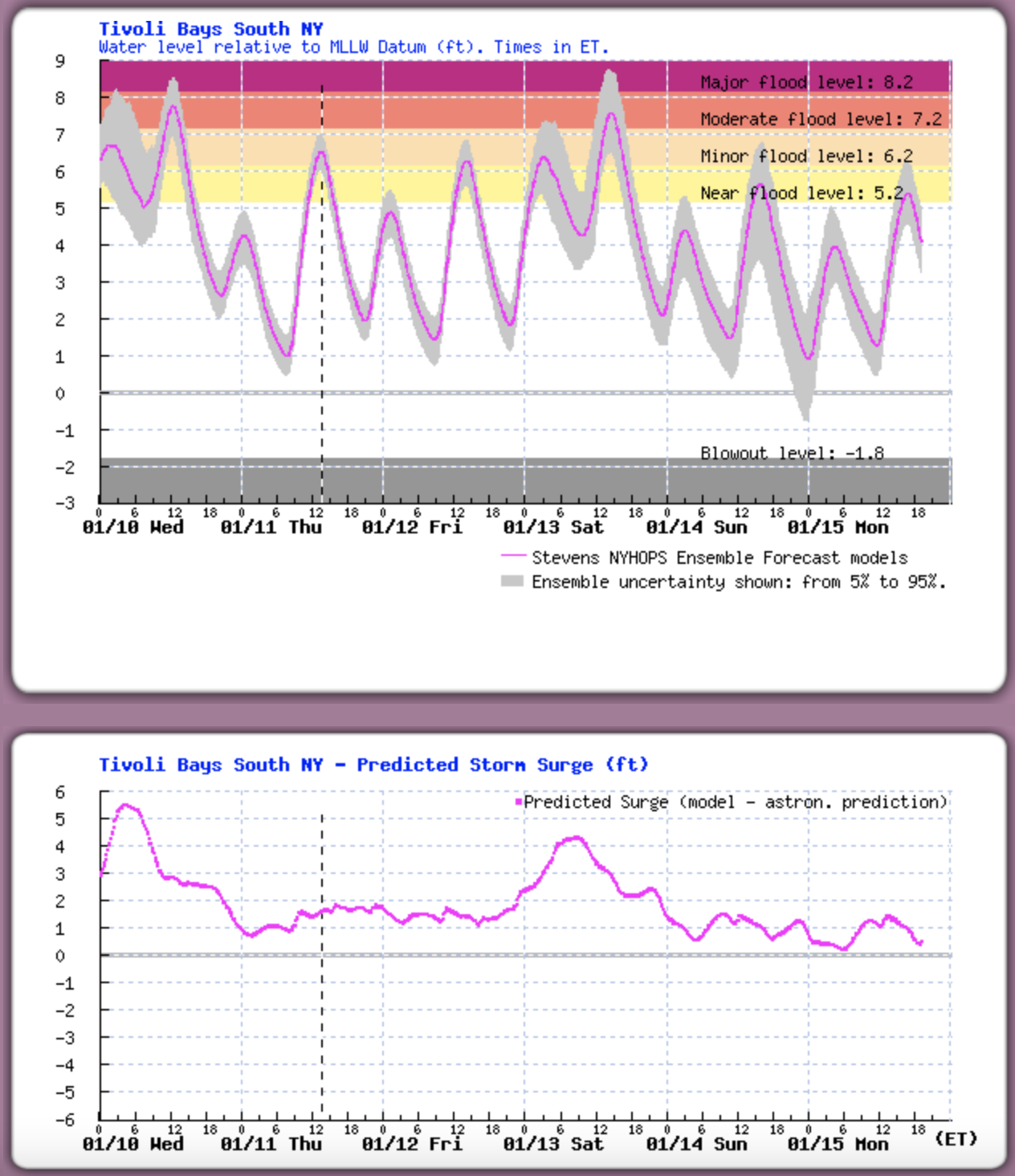
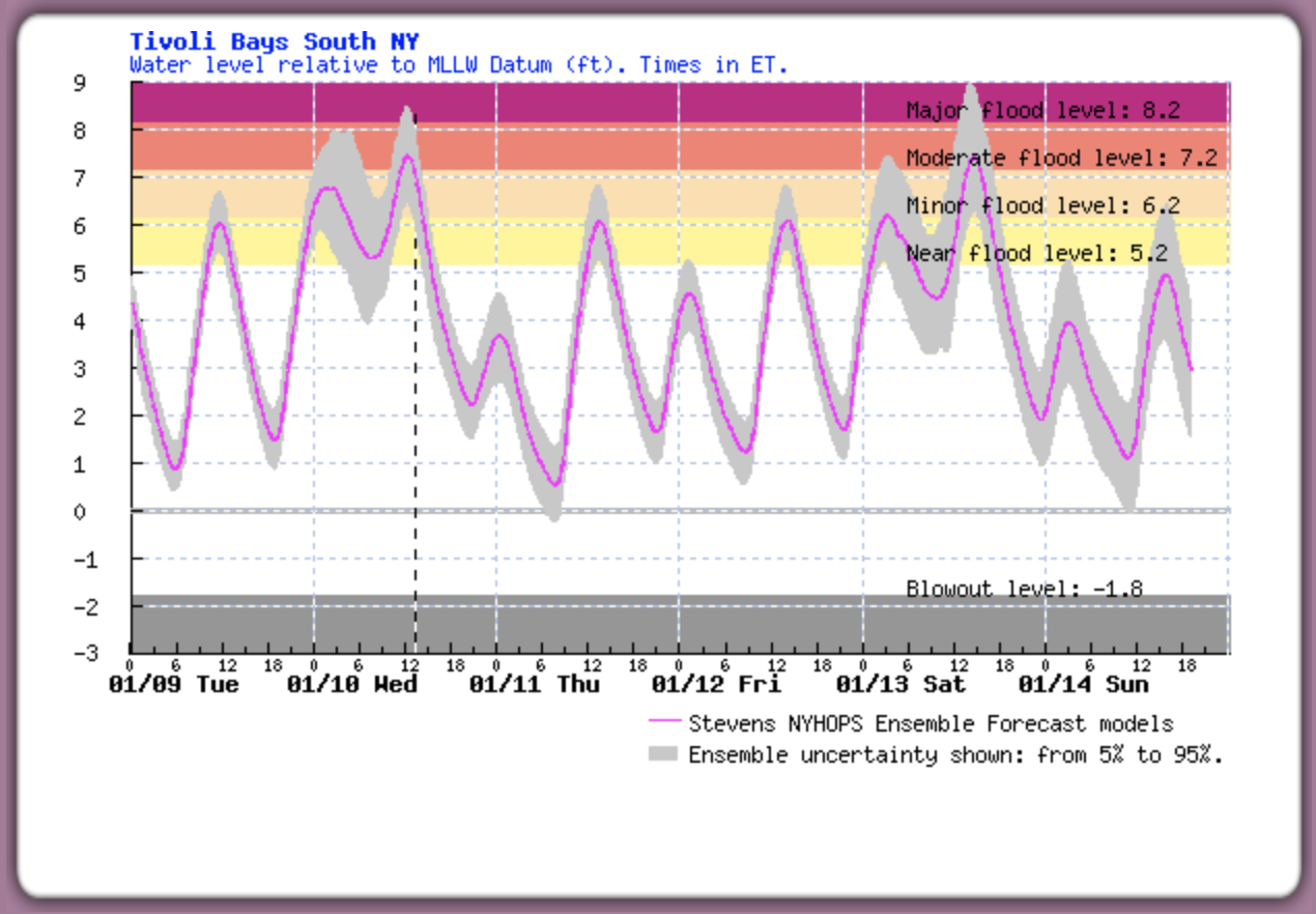
Winter Storm Gerri is forecasted to generate 3 to 4 feet of tidal surge on Saturday afternoon, January 13th, similar to recent flooding caused by Winter Storm Finn on Wednesday. The Stevens Flood Advisory System predicts water levels at least 7 feet above Mean Low Low Water (MLLW) at high tide on Saturday afternoon, which is 3PM at Saugerties. Flooding may cover the pavement of Lighthouse Drive at high tide.
Stevens Flood Advisory System forecast for Tivoli/Saugerties showing predicted surge of 3 or greater coinciding with high tide on Saturday with water levels likely 7.5′ MLLW or greater.
The level of water in the tidal portion of Esopus Creek is minimally affected by the shape or depth of the channel bottom at high tide. No matter how deep the channel is, the tide reaches an elevation established by the water surface elevation in the Hudson River as indicated by the Turkey Point tide station.
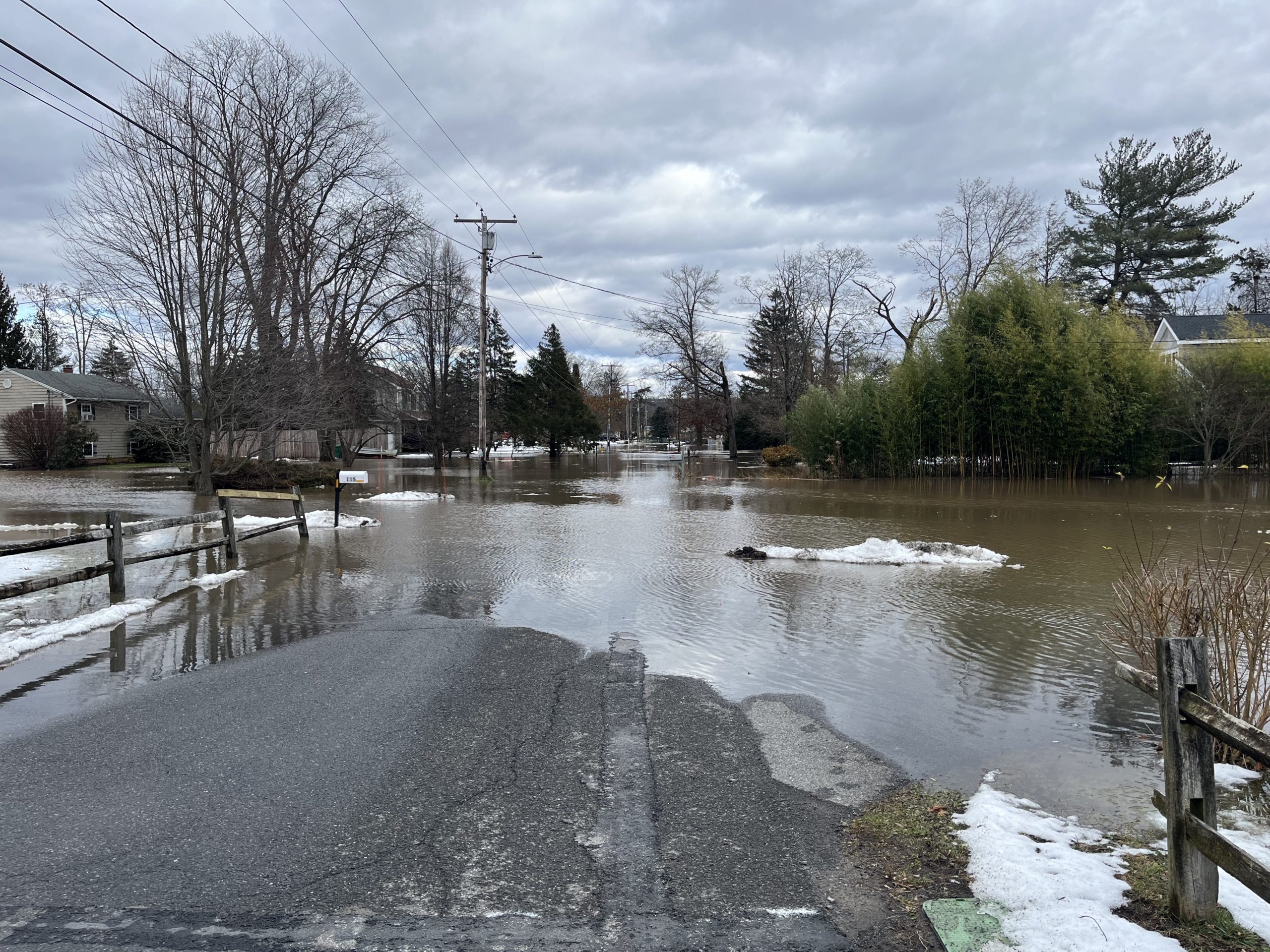
Storm tide from Winter Storm Finn covered Lighthouse Drive at noon on January 10, 2024.
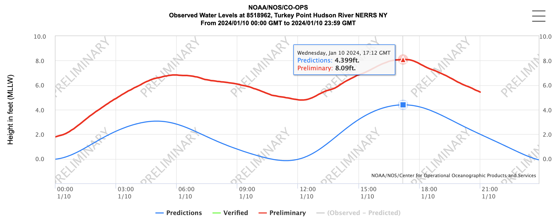
Winter Storm Finn delivered tidal flooding to the Saugerties waterfront midday on Wednesday, January 10, 2024, and Winter Storm Gerri is forecasted to deliver similar flooding on Saturday. On Wednesday morning, the Battery tide gauge in Manhattan registered a surge over 4 feet at low tide and nearly 3 feet at high tide. This surge continued up the Hudson River, and runoff from over 2″ of rainfall on snow overnight added to the tidal surge. According to the Turkey Point tide gauge, the water level crested above 8 feet, which was over 3.5 feet above normal high tide and slightly higher than flood levels on December 18, 2023. At high tide today at 12:15PM in Saugerties, the pavement of Lighthouse Drive was covered in water.
Turkey Point tide gauge showed the water level crested at 8.09 feet at high tide, nearly 3.7 feet above normal.
Tracking Winter Storm Gerri, the Stevens Flood Advisory System at Davidson Laboratory is forecasting 3 to 4 feet of surge on Saturday afternoon at high tide, bringing the water back up to similar levels as Finn. High tide is at 3PM on Saturday, January 13 at Saugerties.
The level of water in the tidal portion of Esopus Creek is minimally affected by the shape or depth of the channel bottom at high tide. No matter how deep the channel is, the tide reaches an elevation established by the water surface elevation in the Hudson River as indicated by the Turkey Point tide station.
Screenshot of Stevens flood forecast for Tivoli/Saugerties showing surge predictions for Winter Storms Finn and Gerri. For the latest forecast, visit the Stevens Flood Advisory website.
Please use the comment form on the website to submit comments and feedback on the draft Plan. The comment period will be open until Monday, January 15th.