NYSDEC and NYCDEP issued a press release announcing turbidity limits and flood protections for the Esopus Creek downstream from the Ashokan Reservoir, as follows:
DEC and DEP Announce Plan to Help Safeguard Ashokan Reservoir Water Quality and Enhance Flood Protections for Lower Esopus Creek
Revised Release Protocol Protects New York City Water Supply and Addresses Lower Esopus Community Concerns about Muddy Water
DEC Adds Lower Esopus Creek to Resilient NY Program to Aid Flood Protection Measures in High-Priority Areas
State Senator Michelle Hinchey and DEP Commissioner Aggarwala Collaborate To Deliver A New Solution To Better Protect Downstream Communities
New York State Department of Environmental Conservation (DEC) Interim Commissioner Sean Mahar and New York City Department of Environmental Protection (DEP) Commissioner Rohit T. Aggarwala, and State Senator Michelle Hinchey today announced actions to limit muddy water releases, AKA ‘turbidity,’ from the Ashokan Reservoir into the Lower Esopus Creek. In addition, DEC announced the addition of the Lower Esopus Creek to the State’s Resilient NY program that identifies strategies to reduce flooding and ice jam formations in high-priority, flood-prone watersheds throughout the state.
“The newly revised protocol for the Ashokan Reservoir is intended to balance our commitment to protecting New York City’s water supply while addressing the concerns of the residents and businesses along Lower Esopus Creek,” Interim Commissioner Mahar said. “The updated policy will minimize the impacts of turbidity in the Lower Esopus and ensure the area remains a healthy and thriving environment for public enjoyment.”
“Today’s historic shift in the Ashokan’s operations emphasizes DEP’s commitment to working closely with all stakeholders to continue our mission of providing the highest quality drinking water possible to half the state’s population,” DEP Commissioner Aggarwala said. “DEP is dedicated to using the gold standard in science to protect and enhance the watershed while working hand in hand with stakeholders helping to improve the quality of life for all residents throughout the region. I want to thank Senator Hinchey for her advocacy, DEC Interim Commissioner Mahar for his partnership, and all local leadership throughout this community for championing this issue. I look forward to continuing our collaboration on the important work that still lies ahead.”
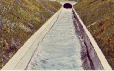
Under newly implemented release protocols, DEP will limit downstream releases of Ashokan Reservoir water when it appears highly turbid, or muddy brown, and expand releases from both the east and west basins rather than restricting releases to only the west basin, which is often more turbid. These actions are formalized in the newly revised Interim Release Protocol (IRP), a set of standards for DEP’s release of water from the Ashokan Reservoir to the Lower Esopus Creek through the reservoir’s release channel.
Since the reservoir’s construction, water releases from the Ashokan have resulted in turbidity in the Lower Esopus Creek, impacting recreation and aesthetics. Based on public input and community concerns about turbidity, the revised IRP limits muddy water releases from the Ashokan unless specifically requested by DEC to support the aquatic habitat.
After conversations with State Senator Michelle Hinchey regarding DEP’s history of turbid discharges into the lower Esopus Creek and the communities’ hopes for improvements, DEP commissioned computerized modeling scenarios to develop potential alternative reservoir operations that would limit muddy discharges.
Senator Hinchey said, “Our Watershed Communities bear the profound responsibility of stewarding the country’s largest unfiltered water system—a duty we embrace with pride, yet one that has impacted our quality of life and created an imbalance in the well-being of our region for nearly a century. Today, in a historic collaboration with my office, DEP, DEC, Ulster County and our municipalities, we make history by delivering a new solution created specifically to protect our downstream communities from turbid releases and enhance flood resiliency against extreme weather. For decades, we’ve known this moment to be possible, that greater equity could be established to do right by our downstream communities. I thank DEP Commissioner Aggarwala for being an action-oriented partner, DEC, and local residents and advocacy groups for working with us to finally reach a mitigating solution.”
The Ashokan Reservoir supplies about 40 percent of New York City’s drinking water each day. DEP utilizes water discharges from the Release Channel to the Lower Esopus Creek as an alternative to reliance on the use of chemical treatment within the water supply, specifically the use of aluminum sulfate, during episodic turbidity events.
Turbidity is typically caused throughout the eastern Catskills by severe weather eroding reddish clay glacial sediment within stream channels and stream banks that is ultimately transported and flows into the Ashokan Reservoir. The Ashokan Reservoir was built with two basins more than 100 years ago to help alleviate turbidity, enabling suspended particles to settle in the west basin before water passes into the east basin.
Ulster County Executive Jen Metzger said, “Today’s announcements by the NYC Department of Environmental Protection and NYS Department of Environmental Conservation represent important steps forward in protecting the water quality of the Lower Esopus and strengthening the resilience of downstream communities to climate change and the impacts of the flooding. I have long advocated for a collaborative approach to decision-making on the management strategy for the Lower Esopus, for a better overall protocol, and for more detailed and more accurate flood studies, and I greatly welcome the significant progress announced today. I want to thank Senator Michelle Hinchey, DEC Interim Commissioner Mahar, DEP Commissioner Aggarwala, Riverkeeper, the Ashokan Reservoir Working Group, our municipal leaders and community stakeholders, and local DEP and DEC teams for all your contributions to these efforts.”
Town of Saugerties Supervisor Fred Costello said, “It’s exciting to be part of this transformative change and I want to thank the DEP and DEC commissioners for this fresh approach to a longstanding problem and thank Senator Hinchey for her leadership on this issue. I also want to thank my neighboring municipal government colleagues past and present for their dedication to this important issue and I think this a celebratory moment for all.”
Village of Saugerties Mayor William Murphy said, “These actions are clearly a win-win and represent a tremendous comprise benefitting all communities along the Lower Esopus Creek. It all comes from an historic cooperative effort between our communities, DEP, DEC, and Senator Hinchey showing what can be done when people work together.”
Town of Ulster Supervisor James Quigley said, “As a government leader with an extensive history working with DEP, seeing an operational change solely meant to benefit communities downstream from the Ashokan is a tremendous step forward and I commend Commissioner Aggarwala for taking this initiative and the local DEP team for their open and ongoing communications. The lower Esopus Creek is a critical and complicated component of our community and I am pleased with this operational adjustment and DEC’s new commitment to improve the creek and help alleviate flooding issues.”
Kingston Mayor Steve Noble said, “I commend the actions NYC Department of Environmental Protection and the NYS Department of Environmental Conservation have taken today, which will help improve the water quality of the lower Esopus Creek. By limiting the amount of turbid, muddy water that would be released from the reservoir and creating a more resilient and healthier lower Esopus Creek, I consider that a significant win for all of the stakeholders. I appreciate the work that all of our partners at the state and local level have done to reach this collective decision.”
Marbletown Town Supervisor Rich Parete said, “I appreciate DEP and DEC working with Senator Hinchey and downstream communities to better regulate releases and insure that all of our concerns are addressed. It couldn’t have been accomplished without DEP and Senator Hinchey’s leadership. It’s been a team effort.”
Town of Hurley Supervisor Mike Boms said, “I am very pleased that the Town of Hurley is kept in the loop when it comes to decision making with lower Esopus Creek. Since becoming supervisor I’ve found DEP to be a cooperating partner and responsive to our downstream communities’ concerns. This historic shift in operations is extraordinarily refreshing and beneficial to the Town of Hurley. Thank you, DEP.”
Riverkeeper’s Dan Shapley, Senior Director of Advocacy, Policy and Planning, said, “We’re pleased to reach this milestone to better protect the Esopus Creek, an important Hudson River tributary that has been called the ‘jewel of the Catskills.’ Riverkeeper is proud to have been part of a coalition effort that has worked for years to find solutions that will prevent excessively muddy water from damaging fish, habitat, and communities along the creek. By committing to releasing cleaner water from the Ashokan Reservoir, New York City has taken an important step toward addressing a core and longstanding concern about water quality in the Lower Esopus Creek.Riverkeeper will continue to work with our partners to ensure that water released from the reservoir is managed to promote ecological health and to mitigate flood risks. The groups, agencies, and elected representatives who have worked with the Ashokan Release Working Group toward this milestone deserve our thanks.”
Resilient NY
DEC also announced the addition of the Lower Esopus Creek to DEC’s Resilient NY Program, with the goal to improve community resiliency to extreme weather events that result in flooding and ice jam formation. Expert consultants retained by New York State are undertaking the state-of-the-art Resilient NY studies at no cost to local municipalities. These studies give communities a blueprint or path forward to abate the worst effects of future flooding.
The Lower Esopus joins 60 other watersheds across New York State already participating in the Resilient NY Program. To date, 43 studies have been completed through Resilient NY; 10 flood studies are underway and seven additional studies will be launched later this year and early in 2025.
More information on Resilient NY is available on DEC’s website.
About the NYC Department of Environmental Protection
DEP manages New York City’s water supply, providing more than 1 billion gallons of high-quality drinking water each day to nearly half of the State’s population, including more than 8 million in New York City and a million more throughout the Hudson Valley. The water is delivered from a watershed that extends more than 125 miles from the city, comprising 19 reservoirs and three controlled lakes. Approximately 7,000 miles of water mains, tunnels and aqueducts bring water to homes and businesses throughout the five boroughs, and 7,500 miles of sewer lines and 96 pump stations take wastewater to 14 in-city treatment plants. DEP has a robust capital program, with a planned $29 billion in investments over the next 10 years that will create up to 3,000 construction-related jobs per year.